Above the surface of the large Dumre Plateau (known also as Belsh), a colony of pretty much round lakes rises randomly in the fields. Nature, does things in a very unrestricted manner and these beautiful lakes are the exact manifestation of nature’s free will. Even though they casually spread over the entire region, an amazing landscape appears surrounded by a beautiful mixture of lands, hills and cultivated fields. In the big picture, it looks like a work of art.
This region is born from an interaction of atmospheric phenomenon that is found everywhere, the karst topology. The karst is a topography formed by the dissolution of rocks such as limestone, dolomite, and gypsum. The drainage systems that work underground create sinkholes and caves. Although, we don’t find any cave in the region, sinkholes that appear time after times form these natural lakes of Dumre. In Dumre (Belsh), there are about 84 lakes spread in all directions. Among them, we find also hills surrounded by agricultural fields. Altogether, these flat lands, lakes and hills side by small villages create a beautiful scenic view of the entire region.
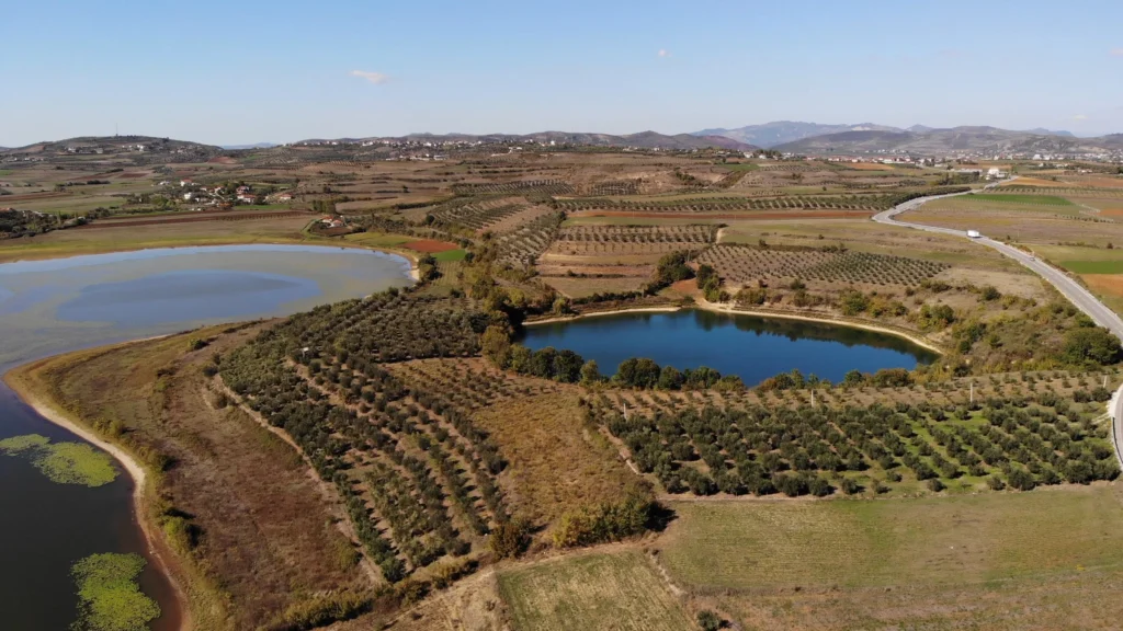
People here have built their lives alongside the lakes and living practices are mainly connected to water cultures and agricultural. Also, there are groups of houses built in some remote parts of the region that enjoy a life of natural serenity. Entering the plateau, located beside a lake, we find the city of Belsh. Belsh is a small citadel with a natural mixture of fertile fields, two lakes, and hills. People in Belsh built the major part of their city on the lock-sides of the hills, watching the lake Belsh. One of the hills is few steps away from the city center, that is populated by pine trees and some low-height vegetation. While, the Lake of Belsh stands out for its natural beauty. This lake occupies an area of 26.8 hectares and it reaches 18 meters in depth. Another lake, located nearby Belsh, is that of the village of Seferan. Naturally formed, as well as all the other lakes, Seferan Lake is 87.5 hectares long with an extreme depth of 20.8 meters, making it the largest lake in the region. I named after the village that is based mainly on the westside of the lake and over the surroundings hills. People here have built their farmlands, businesses, and their lives basically connected to the lake itself.
Going further southwest of Seferan, we find another lake of special importance. This lake is named Merhoja. Its clear-blue water distinguishes lake Merhoja, that occupies an area of 65.5 hectares with its depth reaching 61 meters inside. Few minutes further, there are two other beautiful lakes surrounded by hills that are full of gorgeous olive trees and vineyards. These lakes are called Liqeni i Çestijës and Liqeni i Degës.
The number of lakes found in Dumre (Belsh) expands further. In the southeast side, starting from Lake Seferan, we find the lake of Marinë-Grekan. Its named after the two small villages that reside nearby. The lake is located after the forest of Marina, and it creates a great habitat for the water lily to grow quietly here. Further, in the east direction of Seferan and northerly of lake Marinë-Grekan, there are a group of 6 small lakes that have given life to the village of Gjyralë. These lakes are mainly surrounded by farmlands and flat fields. Whereas, nearby this destination, about 10 minutes’ walk from here, streams the scenic river of Devoll.
As we understand, the entire area has suitable climatic conditions for the cultivation of several agricultural crops, especially bread grains, tobacco, vegetables, vines, and fruit trees. Also, the area it is known for the livestock development. The temperatures here differ same as those of Elbasan and central Albania in general, with a slight softening in winter. Therefore, Belsh is turning in an important tourism destination and has become a must visit place in Albania.